Norbiton Map
MapQuestion
The maps below show an industrial area in the town of Norbiton, and planned future development of the site.
Summarise the information by selecting and reporting the main features, and make comparisons where relevant.
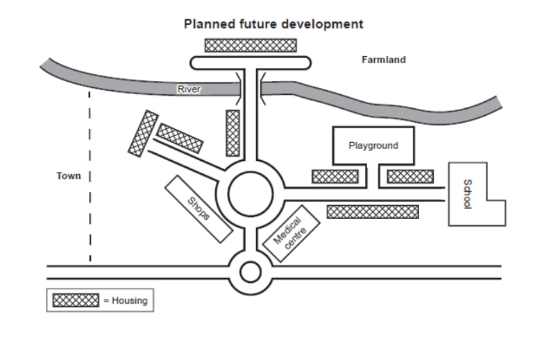
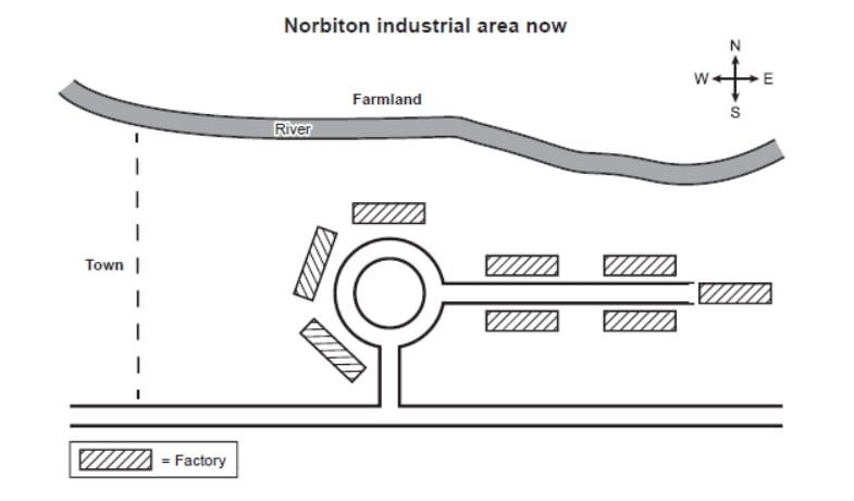
The maps show the current Norbiton industrial area and its proposed redevelopment.
Overall, the area will be transformed from an industrial zone into a residential neighbourhood, with all factories replaced by housing and supported by new amenities — a school, medical centre, shops, and a playground — plus a bridge across the river.
At present, the site contains seven factories along roads radiating from a central roundabout. The river borders the northern edge, with farmland to the north-east and the town to the west.
In the proposed plan, all industrial buildings will be removed and the original roundabout retained. A new roundabout to the south will connect the site to the main road, while housing will replace the former factories in clusters to the north-west, north, and east of the central roundabout.
A new bridge will cross the river to the north, with a road leading to housing on the northern bank. Within the area, a school will sit on the far eastern edge, a playground east of the roundabout, a medical centre to the south-east, and shops to the west. The farmland to the north-east will be partially reduced to accommodate this expansion.
Analysis
Task Response
The overview packs the complete transformation — industrial → residential — alongside all major new features into two tight sentences. The phrase "transformed from an industrial zone into a residential neighbourhood" delivers the macro-change immediately, the gold-standard approach for map tasks.
Key features are selected with deliberate hierarchy. The essay reports the number of factories ("seven factories"), the retention of the original roundabout, the addition of a southern roundabout, and every new amenity with its precise location ("a school will sit on the far eastern edge", "a playground east of the roundabout"). No feature is listed without a spatial anchor.
Comparisons work on two levels: temporal (present vs. future) and spatial (relative positioning). The temporal contrast is explicit in "At present, the site contains…" followed by "In the proposed plan, all industrial buildings will be removed." Spatial comparison appears in the clustering description — "to the north-west, north, and east of the central roundabout" — which shows the writer can compare locations without repeating full clauses.
The essay also captures consequence: "The farmland to the north-east will be partially reduced to accommodate this expansion." Demonstrating knock-on effects of the development — not just listing what changes — is a TR discriminator at Band 8+.
Reusable technique: For map tasks, open the overview with a "transformation verb" (transformed, converted, redeveloped) followed by the before→after identity shift, then enumerate the new features. In body paragraphs, pair every feature with a spatial prepositional phrase so position and change are reported simultaneously.
Coherence & Cohesion
The essay uses three clear paragraph breaks: overview → present → future. This tripartite structure is standard for before/after map tasks and avoids cross-contaminating time periods, the most common CC fault in map responses.
"Overall" opens the overview and signals the macro-perspective shift. Without it, the second paragraph would read as just another body paragraph rather than the evaluative summary it is.
Temporal cohesion is handled without mechanical sequencing words. "At present" anchors the present-tense paragraph; "In the proposed plan" anchors the future. The internal logic does the work — the reader understands the progression because the content itself moves from "contains" to "will be removed."
Spatial cohesion is achieved through prepositional chains. The final paragraph strings together location after location — "on the far eastern edge", "east of the roundabout", "to the south-east", "to the west" — all anchored to the same reference point (the central roundabout). This creates a mental map without needing a diagram.
The bridge paragraph opens with the most significant infrastructure change, prioritising it above the amenities that follow. This is cohesion through evaluation — the writer signals what matters most through paragraph placement rather than explicit signalling phrases.
Reusable technique: In map essays, split body paragraphs by time period (never by feature type), use a single spatial anchor point for all location references in a paragraph, and signal hierarchy through paragraph ordering rather than relying on phrases like "the most significant."
Lexical Resource
The essay demonstrates strong control over transformation vocabulary. "transformed" is precise for total redevelopment. "Replaced by housing" efficiently communicates the substitution without needing a separate destruction verb.
Spatial prepositions are varied and accurate: "radiating from a central roundabout" (outward movement), "borders the northern edge" (linear position), "in clusters to the north-west, north, and east" (grouped proximity). No single preposition is overused, and each carries a distinct spatial relationship.
The verb "retained" for the original roundabout is a precise choice — it communicates that the feature survives the redevelopment, more informative than a neutral "will stay." Similarly, "accommodate" in "partially reduced to accommodate this expansion" implies purpose-driven change rather than arbitrary reduction.
Collocations are native-like: "connect the site to the main road", "housing on the northern bank", "far eastern edge". The phrase "At present, the site contains" is a standard but effective map-task opener.
Reusable technique: Build a map-task vocabulary set before writing: transformation verbs (replace, convert, redevelop, accommodate), spatial prepositions (radiating from, bordering, adjacent to, to the north/south/east/west of), and retention verbs (retain, preserve, remain). Rotate through them to avoid repetition.
Grammatical Range & Accuracy
The essay deploys passive voice strategically to foreground the site rather than the planners. "Will be transformed", "will be removed", "retained", "will be partially reduced" — every major change uses passive. This is correct for map tasks because the agent (planners/developers) is irrelevant; the focus is on what happens to the site.
Participle phrases compress information efficiently. "Along roads radiating from a central roundabout" packs two spatial relationships into one noun phrase. The reduced relative clause "a road leading to housing" embeds direction inside a description without a full clause.
The sentence "A new roundabout to the south will connect the site to the main road, while housing will replace the former factories in clusters to the north-west, north, and east of the central roundabout" demonstrates coordination of two contrasting changes — infrastructure addition versus building replacement — within a single complex sentence using "while."
The final sentence illustrates infinitive of purpose: "partially reduced to accommodate this expansion." The "to accommodate" embeds causation inside a single clause, more sophisticated than two separate sentences.
Reusable technique: For map tasks, default to passive voice for all changes (will be + past participle). Use participle phrases to nest spatial descriptions within noun phrases. Employ coordination with "while" to contrast different types of change in one sentence. Use infinitives of purpose (to + verb) to embed cause-and-effect without separate "this means that" sentences.